Map BCP Superfunds
- Overview
- Changes to Landscape
- Historical Industrial Use
- Areas of Interest
- Environmental Concerns
- Remediation Efforts
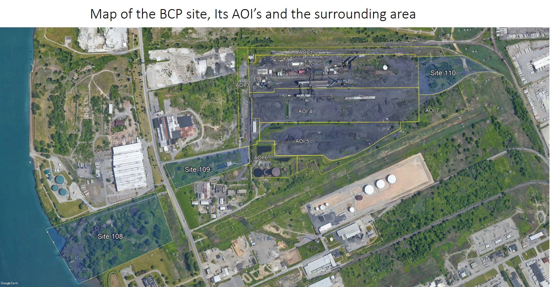
The Brownfield Clean up (BCP) site consists of the original boundary of the Tonawanda Coke plant when it shut down in 2018. The developer has divided the site into 7 Areas of Investigation (AOI).
These include:
AOI 1 – North Rail Corridor: At approximately 6.7 acres, the North Rail Corridor covers an approximately 100-foot-wide (Rows 1 and 2 of the grid) portion of the BCP Site from a gate at the northeast portion of the property to the former parking area (AOI 3). AOI 1 is bounded to the North by a closed fly ash landfill (unrelated to TCC or the BCP Site), to the east by National Grid high voltage transmission rights of way, to the south by AOI 2, and to the west by AOI 3. The north rail corridor is located along the northern boundary of the BCP Site and contains an abandoned rail spur, scale and scale building, a two story brick house (the “mansion”) that was utilized as office space, a large storm water sump (“mansion sump”), excavated soil piles, and miscellaneous debris/trash and abandoned equipment. The mansion sump is the main collection sump for stormwater from the former production area.
AOI 2 – Former Production Area: At approximately 23.6 acres, the Production Area encompasses the area of the BCP Site where the coke was produced, the area in which by-products were separated and managed, and where the boiler house and other auxiliary equipment were located. This area extends from the western boundary of Site 110 to the former parking area, and includes the buildings used for heavy vehicle maintenance and the machine shop. Large areas of this AOI are paved, covered with buildings, or covered by concrete lined secondary containment structures.
AOI 3 – Parking Lot: At approximately 5.8 acres, the Parking Lot represents the property along the western edge of the BCP Site. The parking lot is an elongated area from north to south located on the western side of the BCP Site. The area varies in width, but averages 150-feet wide and is largely within columns A to C of the grid. The Parking Lot is bounded to the west by Vanocur (the offsite industrial property to the west), the closed fly ash landfill to the north, Site 109 to the south, and production and coal and coke yards to the east. The area contains a wood frame building that was historically, and is currently, used for office space. There are three structures on the southeast portion of the parking lot. These structures were used for storage, employee locker/showers, and main electrical access. Additionally, there is a small fiberglass white shed abutting a grated sump (Grid Cell D25) that is the monitoring point for Riverview’s Industrial Sewer Discharge permit. The area is largely paved over with asphalt and concrete that is visibly cracked and rutted.
AOI 4 – Coke Yard: At approximately 23.2 acres, the Coke Yard is located in the middle of the facility and includes the coke yard, coal crusher building, coke screening building, the thawing shed and the former coke rail yard and coke conveyor structure. This Coke Yard is surrounded by other AOIs and Site 110. With the exception of the coal crusher building, the coke screening building and the thaw shed, this area is unpaved. Sedimentation Pool #003 is also located within this area.
AOI 5 – Coal Yard: At approximately 16.2 acres, the Coal Yard lies south of the coke yard. The Coal Yard is the area where coal from suppliers (via barge, rail, and truck) was stockpiled prior to blending and use in the production process. There is a conveyor system that bisects and extends the length of the coal yard from west to east. The Coal Yard contains an engineered storm water sedimentation pool in the northwest corner. A coal conveyor tunnel runs from the coal yard (Grid Cell AJ15) to the coal crusher building (Grid Cell Y13, Building No. 63). The Coal Yard also contains the mixing pad (Grid Cells AE24 to AF24), a containment pad with a concrete floor and poured concrete walls.
AOI 6 – Water Treatment: At approximately 5.7 acres, the Water Treatment area is located on the southwest corner of the BCP Site. There is one metal building and two concrete block buildings that are associated with the four large tanks that are also located in this area. In the northern portion of the water treatment area is the last of the engineered stormwater sedimentation ponds, the storm water retention basin. The large aboveground storage tanks within the secondary containment area were fuel and pentane storage tanks (ST21 and ST22) that were later converted for use as components of TCC’s process water treatment system prior to discharge to the Town of Tonawanda POTW. Since these equalization (EQ) tanks accepted treated process water via an above-grade piping system from the Ammonia Still located in the former production area, the tanks were used for settling and pH adjustment of the treated process water prior to discharge to the POTW.
AOI 7 – South Drainage Area: At approximately 10.3 acres, the South Drainage Area abuts the southern boundary of the BCP Site. No production processes are known to have occurred in this area, but former rail lines, abandoned rail cars, and the South Ditch remain present in this area. In addition to the seven general AOIs identified for the BCP Site, additional AOIs, discussed separately, have been identified as Sites 108, 109, 110, and also Roblin Steel and the Northern Drainage Area as shown in the Site Location and AOI Maps below.